We are nearing the end of the spring ecosystem monitoring survey aboard the NOAA Ship Henry B. Bigelow with less than 3 days left. We are currently in the Gulf of Maine sampling at our 200th station. We will end the cruise with a series of plankton tows and deep-water casts. We’re gathering as much data as we can from large Gulf Stream warm core eddies along our homeward-bound cruise track as we return to Newport, Rhode Island.
Sampling the Wind Energy Lease Areas
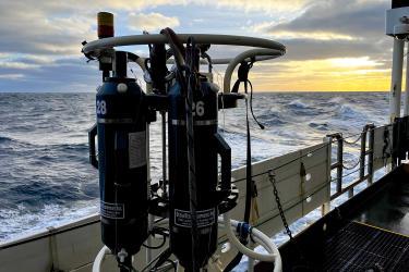
We have been monitoring water transport onto the continental shelf by these Gulf Stream eddies using near-daily sea-surface satellite imagery being sent to the vessel from shore. We are also documenting the movement of plankton and water masses through wind energy lease areas. Equipped with an acoustic Doppler current profiling system to measure the speed and direction of currents, the Bigelow will be recording subsurface water movements as it sails through these areas. We will also collect plankton, water samples, and water column hydrography profiles.
A Completed Survey

The calm weather and good vessel performance have greatly contributed to making this one of the most successful ecosystem monitoring surveys in recent years. We’ve completely sampled all four of the areas studied by ecosystem monitoring surveys:
- Middle Atlantic Bight
- Southern New England
- Georges’ Bank
- Gulf of Maine
In addition to all the data we have collected, the drifter buoys we deployed on Georges Bank 10 days ago have been working flawlessly, transmitting their locations and sea temperatures (track drifter buoys #5301663 and 5301666). But the biggest contributors to this success have to be the personnel on board. The crew, the command, students, and science staff have worked as a close-knit team to make this happen. Thank you! It has been my great pleasure to sail with this team.