In June of last year I woke up to a flurry of messages in our group chat—our team was in full crisis management mode. Two buoys, deployed in partnership with the Applied California Current Ecosystem Studies program, were drifting much further from shore than expected. What if they drift too far for retrieval? If that happened, we would not only lose our equipment, but also our valuable data. Luckily, we were able to find a NOAA vessel traveling farther offshore that was able to pick up one of the buoys. The other is still drifting—as of this writing, it is closer to Hawai’i than San Diego!
If science has taught me one thing, it's that things don’t always go as planned—especially in the ocean! Sometimes a buoy just doesn’t want to cooperate. Maybe it gets caught up in a particularly strong current, maybe it just decides that it needs a nice vacation down to Baja (don’t we all!). The further offshore our buoys drift, the fewer options we have to retrieve them—and it becomes significantly more difficult and expensive to do so. Ideally we need to grab them before this happens. So, how can we more easily identify (or avoid!) these problems in the future?
I’m Taiki Sakai, and I’ve been working with the Southwest Acoustic Ecology Lab for the last 5 years. My work here is mostly behind the scenes. My background is in math and programming, and I use those skills to build tools that make people’s lives easier. After our first buoy went rogue, I set to work creating DriftWatch.
DriftWatch is a tool that automatically creates maps of each buoy’s path with an overlay of the direction and magnitude of the surface currents. It’s a better way to keep track of our buoys at sea and try to stay ahead of potential problems. These are saved to a shared drive so everyone on our team always has access to the most up-to-date information. Seeing where all of our buoys are in near real-time is useful, but what we really want is to try to predict what they might do next.
Trying to accurately predict what an object floating around in the ocean is going to do is incredibly difficult. Fortunately for us we mostly need to answer one important question: is our buoy about to become hard to retrieve? Is it suddenly picking up speed and traveling south? Is it nearing a strong offshore current? There are many factors that can influence the motion of our drifters. After some trial and error we found that just looking at the surface current was usually enough to get a pretty good idea of what would happen next.

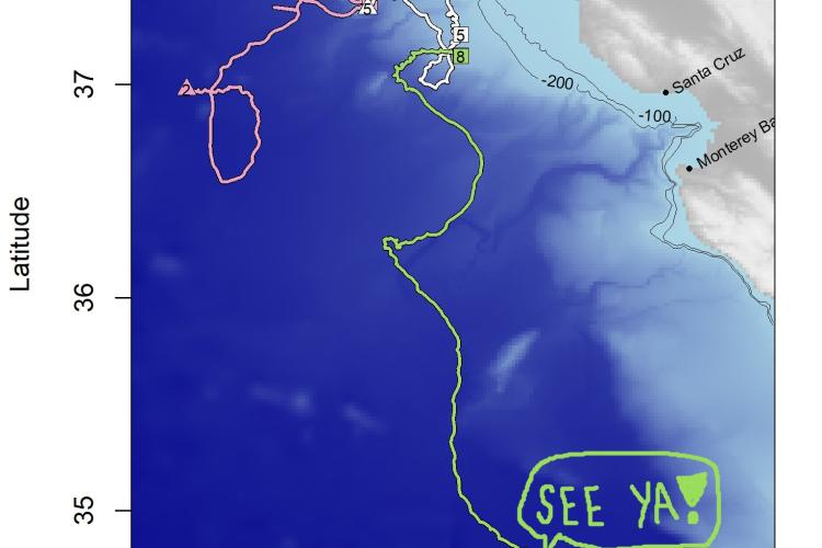
The utility of DriftWatch was put to test right away with one of our most recent deployments. Shortly after deployment, the buoy started drifting directly off shore. Luckily it changed course and headed south before it was out of our reach, but it was on the edge of our comfortable pick-up range. After a few days of continuing on the same course, we saw that the buoy was heading straight toward a large patch of strong offshore currents. We made the decision to have one of our partners pick it up ASAP. Had it reached the offshore current, it is highly unlikely that we would have been able to retrieve it (or at least not without great cost). DriftWatch gave us the chance to pick up our instrument before it became a problem. Score one for DriftWatch!