Hi, I am Ellie Hartman, an intern with the Southeast Fisheries Science Center. I had the incredible opportunity to volunteer on the first leg of the center’s bottom longline survey. When I was asked to fill a position on this survey, I was beyond thrilled! I jumped right on it. Since returning back to school last year, at the University of Miami Rosenstiel School of Marine, Atmospheric, and Earth Sciences, I have had the goal of conducting shark research. My family is astonished by my admiration for shark research. This is mainly because little Ellie had a meltdown while scuba diving when she encountered a nurse shark resting under the rocks. Well, here I am 15+ years later working on a survey that catches sharks. I was able to learn about different species, wrangle live animals, and assist with tagging sharks for scientific research! How the times have changed.
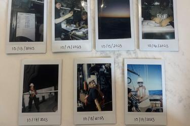
During the 17-day excursion at sea, I learned a lot about the process of collecting data and tagging sharks. Through classes like Shark Ecology and Biology, I had knowledge going into the survey. But, I learned so much more through being around scientists who are shark specialists and getting hands-on experience.
When I returned after my stint on the ship, my family and peers were curious about what I had been doing and the work being done on the survey. There were a lot of great questions asked to learn more. Here is one that I found important to share with everyone who might be wondering.
How do you survey sharks?
To conduct a bottom longline survey successfully, it needs to run like a well-oiled machine. The crew on the vessel strives to complete each longline set (referred to as a station) as consistently as possible. Standardization is key to comparing catches over time and locations. Each member needs to work together to achieve this objective.
Step #1: Bait Hooks

A NOAA Corps Commissioned Officer, the Officer of the Deck driving the ship at that time, comes on through the radio, “10 minutes until station!” A team of scientists stands up promptly and heads to the back deck to bait 100 hooks. Fishing operations are conducted 24 hours a day, so scientists work in two 12-hour shifts, the day or night watch.
The bait used on this survey is—always tasty, at least to sharks—Atlantic mackerel. Thawed bait is stored in a cooler until the team is ready to cut the mackerel into three parts. Each watch, or team, of 4–5 scientists will have one team member cut the bait while the others secure individual pieces to each hook. Each hook makes up part of a gangion, which also consists of a monofilament leader, crimps, and a clip. The hooks sit in two white buckets, each holding 50 gangions. The buckets are critical to organize all the gangions—without the buckets, the gangions would be a tangled mess.
Step #2: The Set Out

After the hooks are baited, it is a quick turnover to the process of setting out. This is when all the teams (ship crew, fishermen, and scientists) work together to get the high-flyer buoys (buoys attached to long poles), weights, and lines into the water. This step of the process is very much like a dance because the timing has to be right on rhythm and everyone needs to be grooving together. Additional instruction and the go-ahead is given from the NOAA Corps Officer of the Deck to the fishermen and deck team members. The deck member shouts, “High-flyer away!” A scientist will push the high-flyer into the water. The high-flyer is attached to the mainline that will then be deployed from a reel into the water. One scientist is sitting ready with a program open on a laptop that monitors all components of the gear as it is deployed. Two scientists work together to attach number tags to each baited gangion and hand gangions one by one to the deck team member to attach to the mainline. The goal is to attach all 100 hooks to the mainline evenly spaced and synchronized to the boat speed.
Step #3: Leave the Line Out in the Water for 1 Hour
During the hour the longline sits in the ocean, the teams are still hard at work deploying and collecting scientific data through an instrument called a Conductivity, Temperature, and Depth water profiler. The CTD collects oceanographic data to characterize environmental conditions, including temperature, salinity, dissolved oxygen, water clarity, and chlorophyll-a concentration, at each location a longline is set. The CTD array is equipped with multiple casings, called Niskin bottles, to collect water samples at various depths when needed. It also has video cameras and lights attached to determine what the bottom at the sampling location consists of (e.g. sand, mud). All team members wear hard hats for this part of the process because the deck team uses a crane to lift the CTD over the side of the vessel. Once the CTD is put into the water, the deck team then lowers the instrument to a depth that the scientists request.

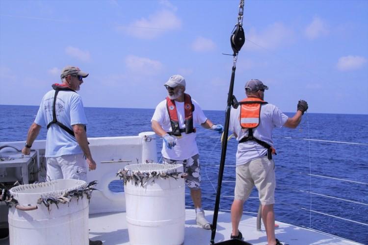
Step #4: Haul Back

“Fish on!” The team anticipates those two words to be shouted as we are hauling back the bottom longline gear. This indicates that an animal is being brought up on the line and the teams need to be prepared to retrieve it. The animal is either brought up by hand or, if it is too large, the deck team lowers a cradle to bring it up. During this process, the empty lines and hooks are placed one by one back into the notched buckets. Another scientist records bait condition data from the hooks or, if an animal is captured, what species it is. The other scientists are standing by ready for measuring, tagging, and collecting samples from each organism retrieved. Once the data are collected from each specimen, the living animals are returned to the water. There are exceptions when we need critical life history information. Some species such as grouper, snapper, and tilefish are retained and samples are collected to determine age, reproductive state, genetics and— in some cases— what they are feeding on.
Just like “The Wobble'' or the “Electric Slide,” everyone needs to step to the same beat and find a rhythm together so that there are no collisions or missed steps. This rhythm throughout the team is vital to the consistency and effectiveness of the survey.
Stay tuned for future blogs on the Southeast Bottom Longline Survey.
Meet the Blogger

Ellie Hartman
Ellie Hartman was born and raised in Breckenridge, Colorado. She was a communications intern, research assistant, and marine mammal observer for NOAA's Southeast Science Center. She graduated from Barry University with a Master's of Business Administration and graduated from University of Miami with a Master's of Professional Science in Marine Conservation. Meet Ellie