One of the great things about gliders–from a piloting perspective, anyway–is that they move slowly. I once made a plot for a presentation that compared a glider’s speed to the speeds of some common animals. For example, a hamster running on a wheel can go as fast as 6 miles per hour. A person walks at an average speed of 3 miles per hour. A giant tortoise walks at a speed of about 0.3 miles per hour.
Gliders are the giant tortoises of the sea. They fly at a speed of about 0.5 miles per hour.
The reason this is great for pilots is that if a glider accidentally hits something in its path, it doesn’t have a catastrophic collision with that object. It just bumps into it. And most of the time, it can bump its way around it without getting stuck or damaged.
But not always. That’s why, as pilots, we’re diligent about monitoring any obstacles the gliders might encounter, and making sure we plan a safe path around them.
In Antarctica, we face three main obstacles: sea ice, ships, and strong currents. I wrote about how strong currents during our 2019/20 glider deployment threw one of our gliders off course for almost a full day. Today I’ll tell you about solid obstacles that may cause the gliders to go bump in the night. Or day.
Sea ice is an unpredictable glider enemy in Antarctica. During our first deployment in 2018/19, sea ice was everywhere. We relied heavily on near-daily satellite images from the U.S. National Ice Center (NIC) to determine whether our gliders were on a collision course with icebergs and to help us plot new, ice-free paths around them. Specifically, we were worried about an iceberg we named “Yacu,” after a mythological South American snake that eats everything in its path. Yacu was enormous–12.5 miles wide–and drifted up from the Weddell Sea into the path of our glider in the Bransfield Strait at an astonishing speed, sometimes moving more than six miles in a single day. About halfway through the deployment, Yacu started breaking up, spawning smaller icebergs that were still huge and posed a significant threat to a glider trying to surface. Without the NIC ice images to track Yacu’s movements–as well as the movements of other icebergs in the area–we might well have flown a glider under an iceberg and gotten it stuck there. And losing a glider means losing all of its valuable data.

Unfortunately for the Antarctic ecosystem–but fortunately for gliders–sea ice has been scarce since our first deployment, although we still consult our regular NIC images to avoid any sea ice surprises. This year, we have a new enemy we haven’t faced before.
Ship traffic.
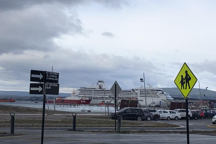
During 2019/20, nearly 75,000 tourists visited Antarctica, mostly on cruise ships. Cruise ship traffic dropped in 2020/21 and 2021/22 because of pandemic-related travel restrictions, but more than 100,000 tourists are expected in 2022/23. In November, when I was in Punta Arenas, Chile for 10 days preparing gliders for deployment, I saw more cruise ships in port than I ever have since I started my almost-annual visits to Punta Arenas in 2009.
Most cruise ships cross the Drake Passage and head to the Gerlache Strait–one of the most stunning landscapes in the world. A few will go to the Bransfield Strait, but a lot will transit through our study area, and they go much faster than six miles per day. While we track ship traffic as diligently as we track icebergs, it’s much harder to predict where a ship might be when a glider comes to the surface. So we do our best.

“Things that go bump in the night” usually refers to ghosts, which I’m not worried about gliders crashing into (or through). But icebergs and ships? Yeah, I worry about those.
P.S. We accidentally did fly a glider under an iceberg during our first deployment. The glider bumped its way along underneath it and eventually surfaced. That was an episode we don’t care to repeat.