
The Tiglax.
Day 1. Well actually it was Day 2, on Day 1, our flight to Dutch Harbor was canceled due to fog. Fog in Dutch Harbor is not uncommon. It frequently grounds the small passenger planes that transport mostly fishermen and scientists to Alaska’s top fishing port. Dutch was to be our departure point, where we were to get onboard the U.S. Fish and Wildlife Service’s research vessel, Tiglax, (pronounced TEKH-LAH). Tiglax is the Aleut word for “Eagle.”
The research team, nine scientists and two communications staff, were headed to Bogoslof Island for this mission. Mission Bogoslof, sounds like something out of a spy novel. Actually, it’s more like heading to Jurassic Park—a remote island 40 miles north of Alaska’s rugged Aleutian Island chain, in the middle of the Bering Sea, complete with an active volcano and quick sand (well, more like marsh mud).

Bogoslof Island.
The team was split up, but with a little luck and crafty negotiations (patience and persistence) by our Field Chief Rod Towell, we were all able to get out on a few added flights on Day 2. However, losing a day was concerning. This was a short survey, only six days, and there was a lot to accomplish in a limited timeframe.

Feeding humpback whales
Tom Gelatt, Alaska Ecosystems Program Manager, and I were the last ones to land in Dutch. But we had quite the welcome. We were greeted by a fan fare of feeding humpback whales in the ocean waters just off the runway. Nice way to start the survey.
All aboard the Tiglax
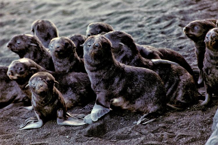
We set sail for Bogoslof after dark to visit one of the few rookeries for northern fur seals in an area also used by Steller sea lions. It would take about six hours to get there. I was sound asleep, so I missed the departure. However, I woke up, in the midst of my first night at sea, to a bit of rocking and rolling. I dared not look out the port hole above my bunk for fear I may be hit with a bout of sea sickness.
After a restless night, I joined the team in the galley, only to find out that this had been a standard night a sea. Fortunately, I felt pretty good despite my limited sleep and I was able to enjoy a delicious breakfast. Living aboard the Tiglax, with comfortable bunks and a chef is an incredible luxury for veteran Bogoslof field team members used to camping in harsh conditions and eating simple fare.
Bogoslof is an unusual and dynamic environment to study seals. It’s actually the tip of a giant underwater volcano. The island was formed in 1796. Another major eruption occurred in 1883 when nearby Fire Island was created. For more than a decade, the volcanic activity continued with the island constantly changing in shape and size. Bogoslof and Fire Islands were recognized for their importance to wildlife (e.g., seabirds and Steller sea lions) in 1909. President Teddy Roosevelt signed an Executive Order protecting them. Bogoslof and thousands of other islands in the Aleutians and around coastal Alaska are now managed as part of the Alaska Maritime National Wildlife Refuge.
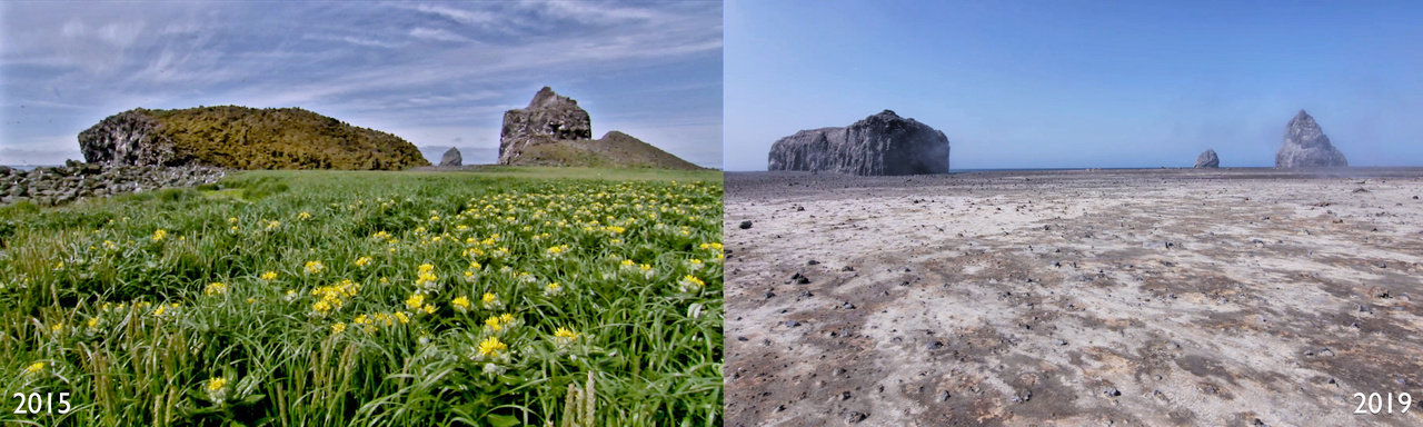
On the left, Bogoslof Island before the last eruption in 2015. On the right, Bogoslof Island in 2019.
A series of eruptions have occurred over the years. The most recent eruption occurred in 2017. It sent a mile high stream of ash and smoke into the atmosphere disrupting air travel in southeast Alaska for several weeks. Today, the island looks a lot different. It’s more than doubled in size and it’s still expanding.
The scientists who visited the site in 2015 described the island as being pretty green. But what I saw this year was a strangely beautiful landscape of barren rock and black sand beaches. As you walk around, it looks like a moonscape. You can smell sulfur, and see steam escaping from the hillsides and the ground, and bubbling pools of water and mud. Remnant but changed Island features include a jagged pinnacle known as Castle Rock on the southern end of the island and Kenyon Dome. These features surround the new steaming summit of this 6,000 foot volcano that lies beneath the Bering Sea.

Tufted puffins on Bogoslof Island.