Refine Results
Region
Management Areas
Map Type
Map Category
Topic
Species Category

Maps

51 resources match your filter criteria.

Recommended Shipping Lanes to Protect Whales Map & GIS Data

Map and GIS data representing recommended shipping lanes to protect whales.
June 13, 2019 - Map ,
NARW_se_recommended_shiplanes.jpg

Smalltooth Sawfish Critical Habitat Map and GIS Data

Map and GIS data representing critical habitat for the conservation of endangered smalltooth sawfish in Florida.
June 13, 2019 - Map ,
map-smalltooth-sawfish-critical-habitat-Florida-SERO.jpg

Atlantic Salmon Gulf of Maine DPS Boundaries

These data represent boundaries of the inland range of ESA-listed Atlantic salmon.
March 07, 2019 - Map ,
atlantic_salmon_illustration.jpg

Storymap: Protecting Marine Species in the Pacific Islands

Take a tour of various cases NOAA Office of Law Enforcement (OLE) in Hawaiʻi conducted to help protect marine animals.
September 21, 2018 - Map ,

Main Hawaiian Islands Insular False Killer Whale Critical Habitat Map and GIS Data

Map and GIS data representing critical habitat for the main Hawaiian Islands insular false killer whales in waters from 45 meters to 3,200 meters (49 to 3,500 yards) in depth surrounding the main Hawaiian Islands (from Ni‘ihau to Hawai‘i Island).
July 24, 2018 - Map ,
Map showing critical habitat areas for main Hawaiian Islands insular false killer whales

Green Turtle Distinct Population Segments Map

Map of threatened and endangered green sea turtle populations worldwide.
March 23, 2018 - Map ,

Humpback Whale Distinct Population Segments Identification Map

Map of distinct population segments of humpback whales worldwide.
March 23, 2018 - Map ,

TurtleWatch

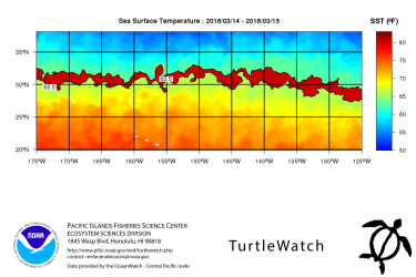
TurtleWatch is a map providing up-to-date information about the thermal habitat of loggerhead sea turtles in the Pacific Ocean north of the Hawaiian Islands. It was created as an experimental product by Pacific Islands Fisheries Science Center to help reduce inadvertent interactions between Hawaii-based longline fishing vessels and sea turtles. Derived from the best available scientific information, the TurtleWatch map displays sea surface temperature and the predicted location of waters preferred by the turtles.
March 22, 2018 - Map ,
turtlewatch.png

Steller Sea Lion Field Season Map

Every year, biologists from the Alaska Fisheries Science Center Marine Mammal Laboratory survey the endangered Steller sea lion during the summer months in Alaska. This map provides a compilation of information collected during the 2016 field season, which included surveys via air, vessel and remote field camps.
January 02, 2016 - Map ,

Atlantic Salmon Gulf of Maine DPS Critical Habitat Map and GIS Data

Critical habitat is habitat needed to support recovery of listed species. When a species is listed under the Endangered Species Act, NOAA Fisheries is required to determine whether there are areas that meet the definition of critical habitat.
June 19, 2009 - Map ,