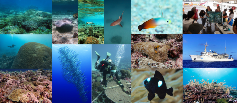
This year, our scientists set sail aboard the NOAA Ship Rainier to collect important scientific data on coral reefs and ocean conditions and to map the seafloor. This mission is called the Rainier Integrates Charting, Hydrography, and Reef Demographics, or RICHARD. It focused on American Sāmoa and the Pacific Remote Island Area from April to September. This work will ultimately help to inform many local and national management efforts. Now that the mission is done and our scientists have returned, they are busy analyzing their data while reflecting on the many highlights they experienced this year.
Study Area
The first mission took place in the Mariana Archipelago in 2022. It was shaped by and dedicated to NOAA Corps Rear Admiral, Richard Brennan. His vision and leadership emphasized teamwork and the importance of hydrography to the nation and the world. In 2023, this legacy continued in the central and south Pacific. NOAA scientists from different backgrounds came together on one mission to collect a wide variety of important data.
- Coral Reef Conservation Program’s National Coral Reef Monitoring Program collected long-term, high quality data on coral reef communities, fish populations, oceanographic conditions, and ocean chemistry to evaluate potential changes in coral reef health and structure, and to inform the NOAA Ocean Acidification Program
- The Office of Coast Survey collected high resolution bathymetric data to update nautical charting products to promote maritime safety, as well as seabed habitat characterization data, sea surface level measurements, and water-column temperature profiles
- The National Marine Sanctuary of American Sāmoa supported the Deep Coral Reef Ecosystem Studies Program with coral surveys in the deep depths (below 100 feet) around the remote islands of Swains and Taʻu
The team visited two archipelagos and eight island areas in the central and south Pacific during the 2023 mission.

Radical Reef Fish and Rare Sightings
Scientists assessed reef fish populations by identifying, counting, and estimating the size of fish at more than 200 survey sites! This data gives us an idea of how many, what types, and where reef fish live. It will help to inform how to manage and support these areas and species. For example, scientists spotted a black butterflyfish in Tutuila; a rare sighting even though the species is native to the region. The last time this species was officially reported in American Sāmoa was in the 1980s!

Studying these ecosystem communities often led to other surprise encounters. At Baker Island, divers saw scalloped hammerhead sharks and manta rays during surveys. Large schools of dolphins and juvenile sharks were often drawn to the boats. A highlight for one team was seeing a whale shark, which can grow to an astounding 55 feet, in the National Marine Sanctuary of American Sāmoa. This was the first ever recorded whale shark sighting at Fagatele Bay!

Counting Colossal Corals
The team of benthic scientists studied the corals and marine life on the seafloor. They assessed the health of existing coral, counted new coral, and took thousands of photographs. Across all of the islands of American Sāmoa surveyed this year, scientists saw higher coral cover, and higher diversity of corals than in most other regions in the U.S. Pacific. They also commonly saw a stony coral species, Isopora crateriformis, in the shallows around Ofu, Olosega, and Tutuila. The species is listed as threatened by the Endangered Species Act, so this is a hopeful sign!

The thousands of coral pictures taken will be used to create three-dimensional models of the reef. Scientists can now use this data, in addition to diver observations, to calculate percent coral cover and other measurements that help determine reef health.
NOAA ships allow scientists to access areas that are not regularly visited. By doing so, they are able to gather data and detect issues that may have previously gone unnoticed. For example, while levels of disease were generally low across the region. However, the reefs around Tutuila had a noticeably higher rate of coral disease including White Syndrome, Black Band Disease, and Banded Fungal Infection. The mission data will be helpful in tracking the spread of coral diseases and monitoring overall health.
Deep-sea coral ecosystems make up a significant part of the coral reefs in American Sāmoa, but only a handful of sites have ever been explored. During the mission, scientists conducted the first ever technical dives in Swains and Taʻu deeper than 130 feet!

Ocean Temperatures and Conditions
The ocean and climate team set out to understand how favorable conditions are for coral growth by measuring ocean temperature and other parameters. Scientists used underwater temperature recorders, small plastic plates called calcification accretion units, and collected seawater samples. Tools like these allow them to monitor how long-term trends in ocean acidification impact corals. The team:
- Deployed an impressive 78 temperature recorders
- Collected 161 water samples
- Deployed 85 calcification accretion units
All of these instruments will be collected when the team returns in 3 years.
Reef growth rates are higher in American Sāmoa than anywhere else in the U.S. Pacific Islands! This is because the warm temperatures and water chemistry in this region are favorable for coral and crustose coralline algae calcification. In the face of climate change, it is promising to see corals still thriving in these conditions. Knowledge gained here can be applied to other places where conditions are less favorable.

Mapping the Seafloor
Another team of scientists mapped shallow areas of the seafloor using two small boats while the Rainier collected data in the deeper areas. These mapping surveys included bathymetry (submarine topography) and backscatter (bottom type) data. Scientists combined them to create detailed three-dimensional maps of the seafloor and its different habitats. These maps will update existing nautical charts, support marine resource management, and increase maritime safety in the region. The team mapped eight island areas including:
- Howland
- Baker
- Tutuila
- Ofu
- Olosega
- Taʻu
- Rose
- Palmyra

Highlighting Collaboration
This unprecedented mission highlights the diversity and range of NOAA’s scientific expertise, and serves as a true example of collaboration. We are proud to honor Rear Admiral Richard Brennan through this mission, and we thank all of the scientists, organizations, and community members who made this mission successful. Scientists are now tackling the important task of compiling summary reports. They look forward to continuing the spirit of collaboration through sharing their findings with local agencies, partners, and communities, to inform both federal and local management strategies.