The Marianas Trench Marine National Monument Draft Management Plan and Environmental Assessment is available for public review and comment from 02/24/21 to 05/25/21.
The draft Monument Management Plan is the proposed road map for protecting and connecting with the Monument and learning about its marine resources and geologic features. It details a series of management activities that are captured in 11 action plans to meet the six Monument management goals.
We are pleased to share the draft management plan for public review and look forward to receiving input from the Commonwealth of the Northern Mariana Islands (CNMI) and Guam communities and the public at large. This is a tremendous opportunity to provide input on the management, research, and education and outreach activities for this special Marine National Monument.
- Dr. Malia Chow, Branch Chief, Marine National Monuments Program, NOAA Fisheries Pacific Islands Regional Office
NOAA Fisheries and the U.S. Fish and Wildlife Service, in cooperation with the CNMI Government, prepared the draft Monument Management Plan. They received significant input from the Mariana Trench Monument Advisory Council. Public comments received during the 2012 public scoping meetings held in the CNMI and Guam helped shape the plan.

The plan defines agency management roles and responsibilities and lays out the goals, objectives, and proposed management activities for the next 15 years. It includes an environmental assessment to evaluate the potential impacts of implementing the proposed management actions.
Your voice matters!
Public comments on the Draft Monument Management Plan and Environmental Assessment provide meaningful and important feedback. Please see the Federal Register notice or Planning Update #5 to learn how to submit comments and for more information. There will be an announcement regarding virtual open house meetings to be held in April 2021.
What Is the Marianas Trench Marine National Monument?

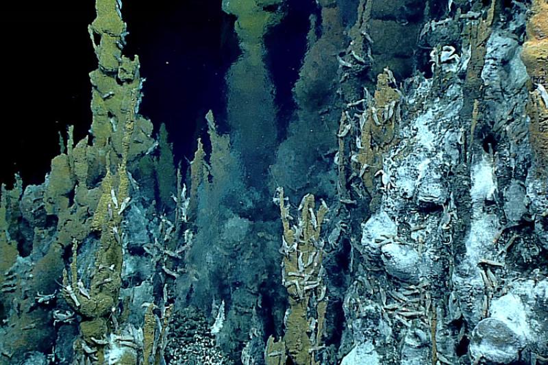
Located in the Mariana Archipelago, the Mariana Trench lies at the Ring of Fire, the most volcanically active region on Earth. The subduction of the Pacific Plate under the Philippine Plate creates the greatest diversity of underwater volcanoes and hydrothermal vent life yet discovered.
This geological phenomenon creates unique underwater environments that support dynamic biological ecosystems. Spectacular volcanic undersea vents, also known as “smokers,” support a wide variety of marine life, including some of the earliest known microbial life forms on Earth.
The Mariana Trench is the world’s deepest trench—Mount Everest could fit into it with a mile of water to spare. The submerged caldera at Maug Island is one of the few places on Earth where photosynthetic and chemosynthetic (using the oxidation of chemical nutrients as a source of energy rather than sunlight) communities of life are known to exist together, creating a natural laboratory to study climate change adaptation. Whales, sharks, dolphins, reef fish, and roughly 300 different coral species flourish here.
As a result of these discoveries, in addition to regional and globally significant exploration and research opportunities, the area was designated as a Marine National Monument in 2009. Spanning 95,216 square miles of submerged lands and waters, the Monument was established to protect the subduction system in the trench, the submerged volcanoes and hydrothermal vents, and coral ecosystems.