Displays spatial data for marine and anadromous species listed under the Endangered Species Act (ESA) in the West Coast Region. The core datasets are ESA-listed species’ ranges and critical habitat.
We created an online application, the Section 7 Mapper, to assist federal action agencies in identifying the ESA-listed species and critical habitat in their project action area.
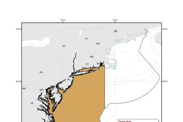
Map depicting where Turtle Deflector Dredges must be used when fishing for scallops in waters west of 71° W. long., from the shoreline to the outer boundary of the Exclusive Economic Zone, from May 1 through November 30.
Map depicting where chain mats must be used when fishing for scallops in waters west of 71° W. long., from the shoreline to the outer boundary of the Exclusive Economic Zone, from May 1 through November 30.