Refine Results
Region
Management Areas
Map Type
Map Category
Topic
Species Category

Maps

52 resources match your filter criteria.

Gulf of Maine Cod Protection Closure V (March 1 - March 31)

The Gulf of Maine Cod Protection Closure V below is closed to all fishing vessels from March 1 through March 31 with a few exemptions. It is one of a series of seasonal closures called the Gulf of Maine Cod Protection Closures.
March 31, 2023 - Map ,

Gulf of Maine Cod Protection Closure IV (October 1 - October 31)

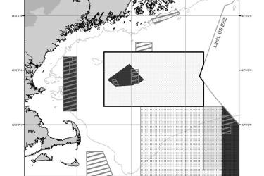
The Gulf of Maine Cod Protection Closure IV below is closed to all fishing vessels from October 1 through October 31 with a few exemptions. It is one of a series of seasonal closures called the Gulf of Maine Cod Protection Closures.
March 31, 2023 - Map ,

Gulf of Maine Cod Protection Closure III (November 1 - January 31)

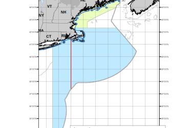
The Gulf of Maine Cod Protection Closure III below is closed to all fishing vessels from November 1 through January 31 with a few exemptions. It is one of a series of seasonal closures called the Gulf of Maine Cod Protection Closures.
March 31, 2023 - Map ,

Gulf of Maine Cod Protection Closure II (June 1 - June 30)

The Gulf of Maine Cod Protection Closure II below is closed to all fishing vessels from June 1 through June 30 with a few exemptions. It is one of a series of seasonal closures called the Gulf of Maine Cod Protection Closures.
March 31, 2023 - Map ,

Gulf of Maine Cod Protection Closure I (May 1 - May 31)

The Gulf of Maine Cod Protection Closure I below is closed to all fishing vessels from May 1 through May 31 with a few exemptions. It is one of a series of seasonal closures called the Gulf of Maine Cod Protection Closures.
March 31, 2023 - Map ,

Cashes Ledge Groundfish Closure Area

Cashes Ledge Groundfish Closure Area is included in the Northeast Multispecies Closed Area Regulations for the Gulf of Maine.
October 01, 2020 - Map ,
Cashes Ledge Groundfish Closure Area. This map includes the Ammen Rock Area Habitat Management Area, Fippennies Ledge Habitat Management Area and the Cashes Ledge Closure Area and Cashes Ledge Habitat Management Area. Map created 7/23/2020.

Georges Bank/Southern New England Scallop Dredge Exemption Area

This dataset depicts the boundaries of the Georges Bank/Southern New England (GB/SNE) Scallop Dredge Exemption Area.
May 13, 2020 - Map ,
GOM_and SG_SNE_Dredge_Exemption_Areas_202058.jpg

Gulf of Maine Scallop Dredge Exemption Area

This dataset depicts the boundaries of the Gulf of Maine (GOM) Scallop Dredge Exemption Area.
May 13, 2020 - Map ,

Redfish Exemption Area

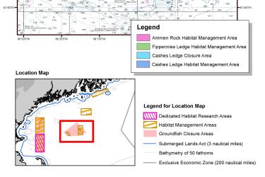
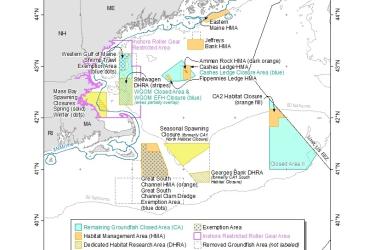
This dataset depicts the boundaries of the Redfish Exemption Area of the Sector Exemption Management Areas in ESRI shapefile format for the NOAA Fisheries Service’s Greater Atlantic Regional Fisheries Office (GARFO).
April 28, 2020 - Map ,
RedfishExemption_MAP_202051.jpg

Omnibus Essential Fish Habitat Amendment 2 Map

OHA2 was initiated in 2004 to review and update the EFH components of all the New England Fishery Management Council's fishery management plans (FMP).
November 01, 2019 - Map ,
Final_Approved_Measures_20180405_low_res.jpg