Refine Results
Region
Management Areas
Map Type
Map Category
Topic
Species Category

Maps

6 resources match your filter criteria.

Summer Flounder Sea Turtle Protection Area Map and GIS Data

Map depicting where summer flounder trawlers in waters off Virginia (south of Cape Charles) and North Carolina must use an approved Turtle Excluder Device.
September 25, 2023 - Map ,
Summer_Flounder_Fishery-Sea_Turtle_Protection_Area_MAP.jpg

Virginia Pound Net Regulated Area Map & GIS Data

Map depicting where pound net regulations are in place in Virginia state waters.
August 28, 2019 - Map ,

Large Mesh Gillnet Restricted Area Map & GIS Data

Map of large mesh gillnet regulations enacted to protect sea turtles
August 27, 2019 - Map ,

Atlantic Sea Scallop Turtle Deflector Dredge Regulated Areas Map & GIS Data

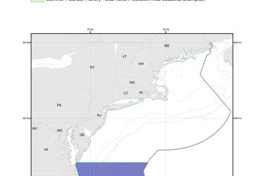
Map depicting where Turtle Deflector Dredges must be used when fishing for scallops in waters west of 71° W. long., from the shoreline to the outer boundary of the Exclusive Economic Zone, from May 1 through November 30.
August 27, 2019 - Map ,

Chain Mat-Modified Scallop Dredge Area Map & GIS Data

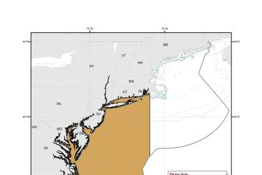
Map depicting where chain mats must be used when fishing for scallops in waters west of 71° W. long., from the shoreline to the outer boundary of the Exclusive Economic Zone, from May 1 through November 30.
August 27, 2019 - Map ,
Chain_Mat-Modified_Scallop_Dredge_Area_MAP.jpg

Hawksbill Turtle Critical Habitat Map and GIS Data

Map and GIS data representing critical habitat for the conservation of endangered hawksbill turtles in the U.S. Caribbean.
June 26, 2019 - Map ,
map-hawksbill-turtle-critical-habitat-Caribbean-SERO.jpg