Refine Results
Region
Topic
Species Category

All Science & Data

24 resources match your filter criteria.

Daydreaming Of Parasites On The Bottom Trawl Survey

Field Fresh Blog: Science in Motion

Fishery biologist Dana Morton welcomes us to the weird and fascinating world of parasites and the stories they can tell us about the fish they infect.
February 05, 2024 - Survey ,
 Female scientist wearing orange jacket and black hat enters data on a computer screen while another scientist measures a fish. Scientists working up the catch at a sampling station. Credit: NOAA Fisheries/Catherine Foley

Most Wow-Worthy 2022 Bottom Longline Survey Moments

Field Fresh Blog: Science in Motion

Marine resource specialist Giovanni Gianesin asked fellow survey participants what their most wow-worthy moments were this fall. From eerie fog and a regurgitated octopus, to huge fish and a feeding frenzy, their answers do not disappoint!
November 29, 2022 - Survey ,
In the foreground, in slight silhouette, a scientist wearing rubber gloves and foul weather gear holds a cage-like piece of equipment at the rail of a boat. Behind him, the sun sets on the horizon of a slightly choppy sea. Field biologist Ben Church deploys an underwater camera system onboard the F/V Tenacious II. Credit: NOAA Fisheries/Giovanni Gianesin

South Island Restricted Area

This dataset depicts the boundaries of the South Island Restricted Area in effect annually from February 1-April 30 in ESRI shapefile format for the NOAA Fisheries’ Greater Atlantic Regional Fisheries Office (GARFO).
August 01, 2022 - Map ,

Massachusetts Restricted Area with State Waters Expansion and Wedge Area*

*NOTE: On March 14, 2024, Judge Young of the United States District Court for the District of Massachusetts ruled that the Consolidated Appropriation Act, 2023, bars the Final Wedge Rule until December 31, 2028. The Court determined that the rule is "void and unenforceable." NMFS is reviewing the decision. 
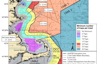
This dataset depicts the boundaries of the Massachusetts Restricted Area in effect annually from February 1 to April 30 in ESRI shapefile format for the NOAA Fisheries Service’s Greater Atlantic Regional Fisheries Office (GARFO).
August 01, 2022 - Map ,

LMA 1 Restricted Area

This dataset depicts the boundaries of the Lobster Management Area One Restricted Area in effect annually from October 1 to January 31 in ESRI shapefile format for the NOAA Fisheries Service’s Greater Atlantic Regional Fisheries Office (GARFO).
August 01, 2022 - Map ,
Lobster Management Area One Restricted Area

Great South Channel Restricted Area

This dataset depicts the boundaries of the Great South Channel Restricted Area in effect from April 1 to June 30 annually in ESRI shapefile format for the NOAA Fisheries Service’s Greater Atlantic Regional Fisheries Office (GARFO).
August 01, 2022 - Map ,

Map of Massachusetts Restricted Area Wedge for Trap/Pot Fishery (Emergency Rule)

Fishermen must remove all trap/pot gear from this area and not set new gear in this area from February 1 to April 30, 2023. This restricted area was also in effect April 1-30, 2022.
February 28, 2022 - Map ,
Map of wedge closure area between MRA and MRA North

Lobster/Jonah Crab Minimum Traps Per Trawl: Northeast Region

The trap/trawl minimums for the Northeast lobster and Jonah crab fishery by area.
October 06, 2021 - Map ,
Northeast Lobster and Jonah crab minimum traps per trawl map

Lobster/Jonah Crab Minimum Traps Per Trawl: LMA 2 and LMA 3

This map shows the minimum traps per trawl requirements for LMA 2 and LMA 3 put in place by the 2021 amendments to the Atlantic Large Whale Take Reduction Plan.
October 06, 2021 - Map ,
Minimum traps per trawl in LMA2 and LMA3

Lobster/Jonah Crab Minimum Traps Per Trawl: New Hampshire

This map shows the new minimum traps per trawl requirements for New Hampshire fishermen put in place by the 2021 amendments to the Atlantic Large Whale Take Reduction Plan.
October 06, 2021 - Map ,
New Hampshire Minimum Traps per Trawl Map