Refine Results
Region
Topic
Species Category

All Science & Data

22 resources match your filter criteria.

Lobster/Jonah Crab Minimum Traps Per Trawl: Maine Zone F

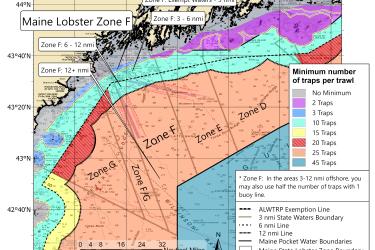
This map shows the new minimum traps per trawl requirements for Maine Zone F put in place by the 2021 amendments to the Atlantic Large Whale Take Reduction Plan.
October 06, 2021 - Map ,
Maine Zone F lobster traps per trawl minimum map

Lobster/Jonah Crab Minimum Traps Per Trawl: Maine Zone E

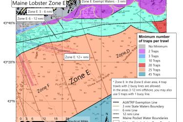
This map shows the new minimum traps per trawl requirements for Maine Zone E put in place by the 2021 amendments to the Atlantic Large Whale Take Reduction Plan.
October 06, 2021 - Map ,
Maine Zone F lobster traps per trawl minimum map

Lobster/Jonah Crab Minimum Traps Per Trawl: Maine Zone D

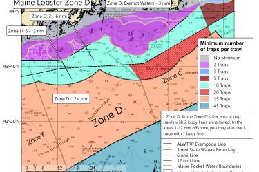
This map shows the new minimum traps per trawl requirements for Maine Zone D put in place by the 2021 amendments to the Atlantic Large Whale Take Reduction Plan.
October 06, 2021 - Map ,
Maine Zone D lobster traps per trawl minimum map

Lobster/Jonah Crab Minimum Traps Per Trawl: Maine Zone C

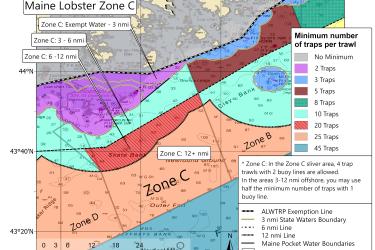
This map shows the new minimum traps per trawl requirements for Maine Zone C put in place by the 2021 amendments to the Atlantic Large Whale Take Reduction Plan.
October 06, 2021 - Map ,
Maine Zone C lobster traps per trawl minimum map

Lobster/Jonah Crab Minimum Traps Per Trawl: Maine Zone B

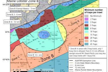
This map shows the new minimum traps per trawl requirements for Maine Zone B put in place by the 2021 amendments to the Atlantic Large Whale Take Reduction Plan.
October 06, 2021 - Map ,
Maine Zone B lobster traps per trawl minimum map

Lobster/Jonah Crab Minimum Traps Per Trawl: Maine Zone A

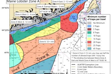
This map shows the new minimum traps per trawl requirements for Maine Zone A put in place by the 2021 amendments to the Atlantic Large Whale Take Reduction Plan.
October 06, 2021 - Map ,
Maine Zone A lobster traps per trawl minimum map

New and Existing Restricted Areas: 2021 Atlantic Large Whale Take Reduction Plan Modifications

Two new restricted areas were added in the 2021 amendments to the Atlantic Large Whale Take Reduction Plan, and two others were modified.
October 05, 2021 - Map ,
New and old restricted areas for lobster and Jonah crab trap pot fishermen

Passive Acoustic Cetacean Map

This mapping tool shows when and where specific whale, dolphin, and other cetacean species were acoustically detected in the North Atlantic Ocean.
June 03, 2021 - Query Tool ,
This illustration shows the variety of technologies that NOAA Fisheries researchers use to record underwater sounds and study marine animals. The seascape shows bottom- mounted and drifting acoustic recorders, underwater autonomous vehicles, Atlantic cod and humpback whale with tags, and instruments deployed from a NOAA ship and small boat. Colored circles show a zoomed-in view of the instruments and indicate the type of data collected: green for real-time data, orange for archival data, and blue for active

Recovery Action Database

Tracks the implementation of recovery actions from Endangered Species Act (ESA) recovery plans.
February 10, 2020 - Database ,
RAD image.JPG

Other Southeast Gillnet Waters

This dataset depicts the boundaries of the Other Southeast Gillnet Waters.
October 12, 2019 - Map ,
Other-Southeast-Gillnet-Waters-MAP-NOAA-GARFO.jpg