Equipment recently deployed in the Chesapeake Bay is already giving scientists and resource managers insight into fish behavior. Arrays of acoustic telemetry receivers let researchers know when fish that have been tagged swim near the receivers. The data is helping researchers increase knowledge about fish, their migrations, and how they use different habitat areas in the Chesapeake Bay.
Acoustic Receivers Around the Bay
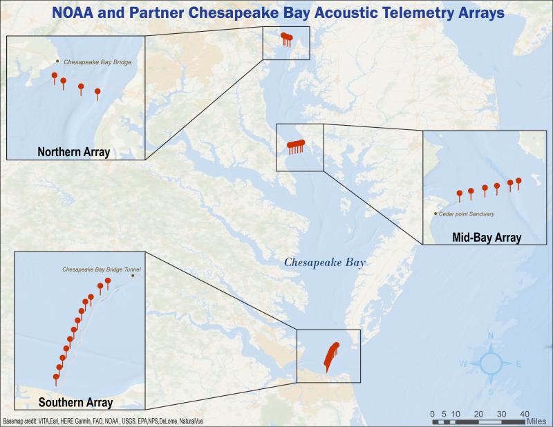
The NOAA Chesapeake Bay Office (NCBO) is working with partners to help researchers get data from five groups of receivers. Three arrays form gates across strategic points in northern, middle, and southern bay.
Northern Array
The northern array includes four receivers across the Bay near the Chesapeake Bay Bridge, close to Annapolis. This array, funded by NCBO, is operated in partnership with the Maryland Department of Natural Resources.
Southern Array
This array is composed of 12 receivers near Virginia Beach. It is also funded by NCBO and is operated in partnership with the Virginia Marine Resources Commission.
Mid-Bay Array
This array of six receivers is managed by the University of Maryland Center for Environmental Science. It’s located near the mouth of the Patuxent River, on Maryland’s Western Shore.
NOAA Chesapeake Bay Interpretive Buoy System
All five buoys currently deployed in the NOAA Chesapeake Bay Interpretive Buoy System are outfitted with receivers.
Choptank River
We have placed three receivers in the Choptank River near oyster restoration projects. These receivers are on loan from NOAA Fisheries’ Northeast Fisheries Science Center.
Impressive Data after Just One Year
Data from each of the roughly 30 total acoustic receivers is delivered to researchers via the Mid-Atlantic Acoustic Telemetry Observing System.
Even though the arrays have only been in the water for less than a year, they have reported lots of action. The southern array has provided a great set of data for researchers. From March to October 2021 those receivers noted:
- 3,824 “hits” of identifiable, tagged fish
- Six different species
- Fish involved in 14 research projects have been identified
And while the statistics are pretty cool, the data behind those stats are helping researchers and resource managers learn more about these species. Learning more about fish migrations helps us understand more about their life cycles and how the species interact. It can also inform efforts to sustainably manage species that are commercially harvested.
Telemetry Data Gives Researchers Important Insight
Dr. David Secor, a professor at the University of Maryland Center for Environmental Science, is researching endangered Atlantic sturgeon. He is studying how they access the only river in Maryland in which they are known to spawn: the Nanticoke River-Marshyhope Creek system on the Delmarva Peninsula.
Understanding where sturgeon are can help resource managers protect them. “Knowing Chesapeake mainstem corridors for migrations by this endangered species could inform issues pertaining to influence of climate on spawning run behaviors, vessel strike threats, and assessment of spawning run sizes in recovery plans for the species,” Dr. Secor notes.
Telemetry lets scientists know when a fish swims by a receiver, delivering information about where and when fish spend their time. When there are multiple receivers and multiple arrays, the data can paint a rich picture of how fish move throughout the year and what may affect their movements.

“By tracking individual fish over hours, days, and seasons unique perspective is gained on how movements and migrations are influenced by climate change, water quality and pollution, artificial structures and management actions that cannot be gained from traditional fishery dependent or fishery independent survey programs. Telemetry allows fish to tell their own stories,” said Dr. Secor.
There are important uses for this information. “Striped bass telemetry data will inform assessment models that allow reference points and actions to be tailored to the Chesapeake Bay vs. Atlantic segments of the Northeast U.S. Atlantic striped bass stock,” Dr. Secor explained. “Telemetry of migratory fishes moving through offshore wind lease areas will inform managers on risks of turbine construction impacts.”
Data from Tagged Fish Supports Management of Commercial, Recreational Species
Scientists seeking to learn more about specific species aren’t the only users of telemetry-based observations. In the Chesapeake Bay, fisheries are managed by the states. In Virginia, that effort is led by the Virginia Marine Resources Commission (VMRC), where Ethan Simpson serves as biological sampling program manager.
He notes that learning more about commercially and recreationally important species can help resource managers develop more tailored regulations. That helps protect those species when and where they need protection (for example, when they are spawning). It also lets anglers target them in other times and places.
“Striped bass and cobia represent major sources of income for not only commercial watermen and fish houses, but also charter captains, tackle shops, hotels, and every service in between. With modern advances in acoustic telemetry technology we hope to better identify how these species utilize the Bay and where they go when they are outside of Virginia's waters as local and global climates continue to change,” said Simpson.
VMRC plans to use funding from the Atlantic States Marine Fisheries Commission (ASMFC) and Virginia’s Chesapeake Bay Restoration Fund to purchase tags for fish.
“The tracking data collected from this program will not only tell us the migratory routes of the species, but also better inform us where spawning aggregations typically occur and the timing of such events. Furthermore, over the lifetime of the program, patterns of immigration and emigration will become apparent, allowing both VMRC and ASMFC to better tailor seasonal closures and other regulations to further protect the species from overexploitation,” Simpson detailed.
Telemetry data relies on a complex network of technology to acquire the data, as well as a team of partners to collect and share that data. We get to work with some terrific partners in this work. We couldn’t agree with Simpson more when he says, “Successful acoustic telemetry programs rely on cooperation and communication across large geographic areas and we hope that this work can provide a model for federal agencies, state agencies, and research institutions to emulate going forward.”