Unsupported Browser Detected

Internet Explorer lacks support for the features of this website. For the best experience, please use a modern browser such as Chrome, Firefox, or Edge.

Near Real-time Temperatures from the Bering Sea Bottom Trawl Survey 2023

Water temperature affects many species' spawning times, access to food, growth rates, and overall range. Collecting temperature data helps better understand the species’ habitats and the larger ecosystem.

NOAA Fisheries AFSC Groundfish Assessment Program conducted the northern Bering Sea and eastern Bering Sea bottom trawl surveys. The near real-time ocean bottom temperatures depicted were collected May 28-August 20. On August 20, stations R-19 (60.67°N, -169.38°W; >4–5°C) and R-20 (60.67°N, -170.06°W; >1–2°C) were surveyed by the F/V Alaska Knight. No stations were surveyed by the F/V Northwest Explorer. There are no stations planned for August 21. Credit: NOAA Fisheries
Map of the ocean bottom temperatures from the 2023 eastern and northern Bering Sea bottom trawl surveys aboard the F/V Northwest Explorer and F/V Alaska Knight. Updated colors: This year in an effort to make the heatmaps more accessible to a broader audience a new color scheme was used for our heatmaps. However, given feedback we have received we are reverting back to the colors used in previous years.  If anyone is having difficulty reading the maps, please contact us at afsc.webmaster@noaa.gov and we would be happy to provide the alternative color scheme we test-cased this year. Credit: NOAA Fisheries

Survey Progress and Bottom Temperatures

The goal of the eastern Bering Sea and northern Bering Sea bottom trawl surveys are to collect data on the ranges and populations of fish, crab, and other bottom-dwelling species in the Bering Sea. Temperature heavily influences these ranges and populations, so ocean bottom temperatures are recorded from all the areas the survey collects catch samples. During this year's surveys, we are sharing these temperatures in near real-time. 

Survey Progress

This PDF provides static maps of each day's progress and bottom temperatures (Celsius). The last page includes a map of the full eastern and northern Bering Sea survey grid with bathymetry at 50m, 100m, and 200m.

NOAA Fisheries AFSC Groundfish Assessment Program conducted the northern Bering Sea and eastern Bering Sea bottom trawl surveys. The near real-time ocean bottom temperatures depicted were collected May 28-August 20. On August 20, stations R-19 (60.67°N, -169.38°W; >4–5°C) and R-20 (60.67°N, -170.06°W; >1–2°C) were surveyed by the F/V Alaska Knight. No stations were surveyed by the F/V Northwest Explorer. There are no stations planned for August 21. Credit: NOAA Fisheries
Animated map of the ocean bottom temperatures from the 2023 eastern and northern Bering Sea bottom trawl surveys aboard the F/V Northwest Explorer and F/V Alaska Knight. Credit: NOAA Fisheries
Map showing survey stations that scientists use for recording temperatures in Alaska
Map of the eastern Bering Sea and northern Bering Sea 2023 survey stations with the 50m, 100m, and 200m bathymetry lines. Credit: NOAA Fisheries.

Each spring, a cold pool is formed by the previous winter’s melted sea ice in the Bering Sea. The location and temperature of this cold pool changes from year to year and affects fish, crab, and other bottom-dwelling species movement and ranges. Due to warming ocean temperatures in the Bering Sea, scientists track and closely monitor the location of the cold pool by collecting ocean bottom temperatures at each station. Learn more about temperature anomalies, the cold pool, and how these temperatures have changed over time.

Learn more about the eastern Bering Sea and northern Bering Sea surveys in our 2023 research briefs. All data collected on the surveys are publicly accessible from: 

Survey Dates

The eastern Bering Sea bottom trawl survey is scheduled to run from May 17-July 29. The northern Bering Sea bottom trawl survey will take place afterwards, from July 29-August 24th. This year, start dates are staggered for the two vessels conducting the surveys, the F/V Alaska Knight (departing Dutch Harbor on the 17th of May) and the F/V Northwest Explorer (departing Dutch Harbor on the 21st of May). We will keep the communities informed of our survey progress by posting daily updates of our survey progress via the website and social media.  As we have always done, we will share preliminary results from the survey via Strait Science, radio and newspaper interviews, and community presentations virtually if there is interest.

Left image is the vessel called the Northwest Explorer and image on the right is the vessel called Alaska Knight.
Left image: F/V Northwest Explorer. Credit: International Year of the Salmon. Right image: F/V Alaska Knight. Credit: NOAA Fisheries.

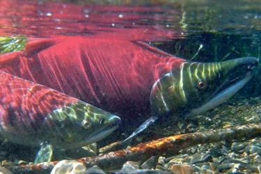
Pictures from the field

What do surveys in the Bering Sea look like? Explore our new photo gallery to see this current survey’s photos from scientists in the field. These photos show the incredible places that NOAA scientists go and showcase our mission in ways that words cannot.